
Program
Topography and thermal front influence the water transport from the northern Laotieshan Channel to the Bohai Sea interior in summer
Date:2023-03-31
Hits:5528
Recently, the research team led by Zhou Feng, a researcher in the field of offshore dynamics and ecological environment from the SIO, published the research achievement entitled “How do topography and thermal front influence the water transport from the northern Laotieshan Channel to the Bohai Sea interior in summer?” in Deep Sea Research Part II: Topical Studies in Oceanography. The first author is Xu Yinfeng, a doctoral candidate jointly trained by the SIO and the Ocean University of China, and the corresponding author is researcher Zhou Feng. The co-authors include associate researcher Meng Qichen and engineer Zeng Dingyong from the SIO, senior engineer Yan Tao of the North Sea Bureau of the Ministry of Natural Resources, and researcher Zhang Wenyan of the HZG-IFK (Institute of Coastal Research of Helmholtz-Zentrum Geesthacht).
Water quality in Bohai Sea (BS) has been greatly improved by continuous treatment, but the speed of water quality improvement does not match the strength and intensity of treatment, and the challenge of overall improvement remains formidable. This is mainly because, on the one hand, the economy of Circum-Bohai Sea Region is relatively developed, and the pollution flux from surrounding areas into the BS remains at a high level; On the other hand, the BS is connected to the Yellow Sea only through the Bohai Strait, and its water renewal largely depends on the water exchange between the BS and the northern Yellow Sea (NYS). Previous studies have shown that although the peak water transport through the Bohai Strait occurs in summer, the spatially averaged water residence time of the BS shows no significant decrease compared to other periods. The main objective of this study was to reveal why the strong water exchange between the BS and the NYS in summer does not enter the BS and why it does not lead to a significant improvement in the overall water quality of the BS. Based on the international advanced ROMS model, a three-dimensional numerical model of ocean circulation including the BS and the Yellow Sea is constructed in this paper. The model result is applied to unravel the structure and dynamics characteristics of the summertime NYS water transport from the northern Laotieshan Channel to the BS interior and the ω-shaped circulation formed.
In summer, the BS monsoon is weak, and density current is the main component of low frequency circulation. Under the influence of terrain, the BS has a similar density structure and a matching stable circulation structure every summer. In order to study the average state of water transport, this study is mainly based on the forcing of climate states to drive the model. In order to fully understand whether the climate state results are sufficiently representative, the study also simulated the thermohaline flow characteristics in 2006 and 2016 based on the years of existing observation data. The results prove that despite a large amount of the NYS water enters the strait, they are confined to the Laotieshan Channel between the Central Bank and Dalian surrounded by a strong Ω-shaped tidal front and could not move further north into the Liaodong Bay coupled with a significant topographic sill blocking effect on its northern side (Figures 1 and 2). The strong along-front flow steered by the topography forms a counter-clockwise circulation pattern in the strait zone, resulting in most of water southward movement east of the Central Bank, then joins the outflow south of the strait and leave for the NYS. The Central Bank and the topographic sill north of the Laotieshan Channel act as a barrier that significantly reduces the water exchange between the strait zone and the BS interior, in particular the Liaodong Bay. Particle-tracking experiments suggest that less than 10% of particles released in the NYS could finally reach the BS interior, and among of them only a small portion of them (<0.5%) could move further north into the Liaodong Bay. Momentum diagnostics suggest that the water transport northwest of the strait is dominated by geostrophic balance in the Ω-shaped frontal region.
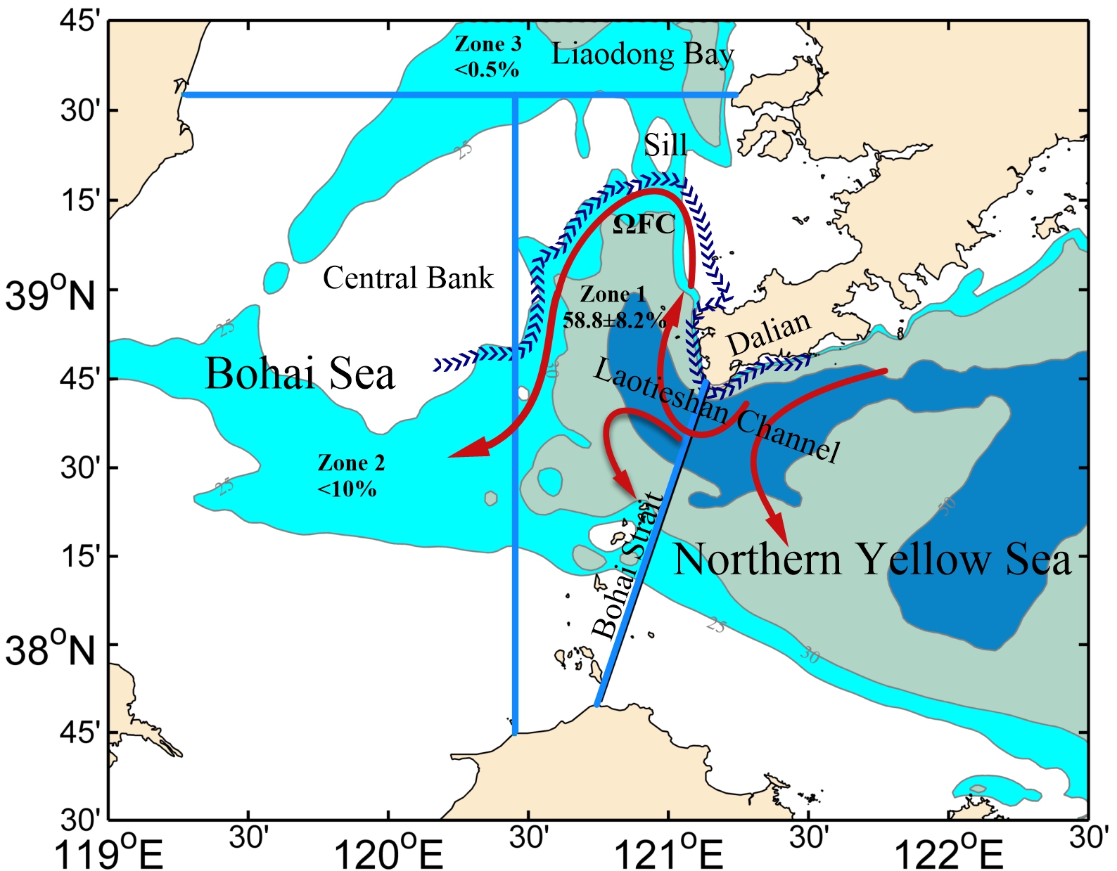
Figure 1 Schematic diagram of water transport from the NYS to the BS interior in summer (red arrow). Contours represent isobaths of 25, 30 and 50 m. The percentage represents the average value of particles entering different regions. The blue strip line represents the position of the Ω-shaped tidal front.
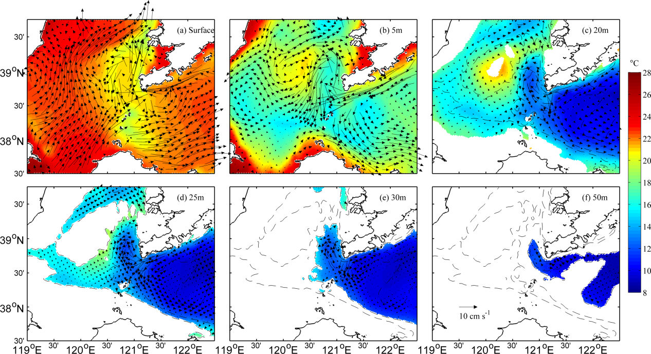
Figure 2 Average circulation near Bohai Strait in summer. (a) Surface layer; (b) 5 m layer; (c) 20 m layer; (d) 25 m layer; (e) 30 m layer; (f) 50 m layer. The black dashed lines are isobaths of 25 m, 30 m, 50 m and 60 m.
In addition, considering that the mixing of tides and tidal residual current may also play a key role in the mean circulation of the BS and the Yellow Sea, the numerical simulation experiment without tide is also designed in this study. The comparison of the simulation results with and without tides shows that the tide promotes the transport of surface seawater from the NYS to the BS interior. Compared to the monthly average climate state wind field, the real wind field with high temporal resolution (including synoptic-scale events) can promote water transport from the strait to the BS interior by adjusting the baroclinic and baroclinic gradient forces.
The offshore ecological environment has been concerned permanently by the SIO. Since undertaking the major project of the National Natural Science Foundation of China “Bohai Sea ecosystem dynamics and sustainable utilization of biological resources”, the SIO, together with University of Hamburg, the Ocean University of China, the Yellow Sea Fisheries Research Institute of the Chinese Academy of Fishery Sciences and other Chinese and foreign cooperation units, has made a large number of investigations and studies on the marine circulation and coastal wetland protection in the Bohai Sea, constantly offered suggestions for the sustainable development of the Bohai Sea, and helped deepen the strategic goal of pollution prevention and control.
Paper Citation:
Xu Y., Zhou F., Meng Q., Zeng D., Yan T.,Zhang W., 2023. How do topography and thermal front influence the water transport from the northern Laotieshan Channel to the Bohai Sea interior in summer? Deep Sea Research Part II: Topical Studies in Oceanography. 208, 105261, doi:10.1016/j.dsr2.2023.105261.

